In this article you will learn how many continents are there on earth and all the detailed information about them.
About 71% of the earth's surface is occupied by the World Ocean, and the remaining land surface is distributed between continents.
By definition, a continent is a large massif of the earth's crust rising above the level of the World Ocean. Oddly enough, the number of continents is not generally accepted, ranging from 4 to 7 in different countries. In the post-Soviet space, there are 6 continents with the following area of million km 2:
- Eurasia – 54;
- Africa – 30;
- Antarctica – 14;
- Australia – 9.5;
- North America –24;
- South America -18.
The largest continent, Eurasia, includes two parts of the world - Europe and Asia. The two American continents, on the contrary, make up one part of the world - America. The remaining continents coincide with the parts of the world of the same name.
Mainland - Eurasia
Eurasia accounts for a third of the entire earth's landmass, where ¾ of the total population is concentrated. Here are the largest countries in the world in terms of territory and population. Russia occupies over 17 million km2, and the population of China at the beginning of 2016 was 1 billion 375 million people.
The territory of Asia occupies 80% of the entire Eurasian continent. With an average altitude of 830 m above sea level, this continent is the highest.

Eurasia owns several more geographical records:
- Chomolungma (Everest) is the highest mountain on the planet (8848 m);
- Baikal is the deepest lake on Earth (1642 m), and the Caspian Sea is the largest;
- The Mariana Trench of the Dead Sea is the deepest ocean floor (about 11 km);
- the shallowest is the Sea of Azov, and the largest is the Mediterranean.
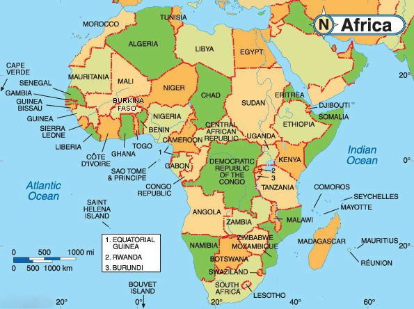
Continent - Africa (how many continents are there on earth)
The African continent has the largest number of states - 53. Africa is home to the largest diamond deposits and the highest level of diamond mining, often illegal.
This fact has virtually no effect on the material standard of living, which here, with rare exceptions, is very low.
Africa is home to the largest desert on earth, the Sahara. Africa stands out for its richness of animal life, among which the cheetah is the fastest animal on the planet.

Everyone knows the Egyptian pyramids. But few people know that there are many more pyramids in the largest African country - Sudan. It’s hard to believe, but in Africa, in Morocco, there is a good ski resort called Ifrane, located at an altitude of 1600 m.
Continent - Antarctica (how many continents are there on earth)
The ice of Antarctica makes up 90% of all the earth's ice and contains 70% of all the earth's fresh water reserves. The average ice thickness exceeds 2 m. The largest iceberg discovered was 300 km long and 37 km wide.
Surprisingly, it is Antarctica, and not Africa, that is the driest continent on earth. Only 10 cm of precipitation per year is recorded here - less than in African deserts.

Antarctica belongs to no one. There are no time zones here either. No one lives permanently on the mainland, and the temporary population consists of participants in scientific expeditions.
The climate of Antarctica is too harsh even for polar bears, which are not there, contrary to popular belief. Most of the continent is inhabited by penguins.
Continent - Australia (how many continents are there on earth)
The smallest continent on earth consists of a single state - the Commonwealth of Australia. A third of the continent is desert, making Australia the driest inhabited continent.
At the same time, the Australian Snowy Mountains receive more snow than the Swiss Alps.
Tasmania, one of 6 Australian states, has the cleanest air in the world, and the country as a whole is famous for its ideal ecology.

The longest road in the world in the Nullarbor Desert is 146 km long, and the Great Barrier Coral Reef stretches for 2600 km.
There are a lot of kangaroos, sheep, and especially rabbits in Australia. It was to protect sheep pastures from rabbits and dingoes that the longest fence in the world, 8.5 thousand km, was built.
Continent - North America (how many continents are there on earth)
The border between the United States and Canada, which is almost 9 thousand km, is not guarded. Partially it passes through residential buildings. The island of Greenland, geographically belonging to the North American continent, belongs to the European state of Denmark.

The Bay of Fundy on the east coast of Canada is home to the highest tides in the world's oceans, reaching 18 m. Under the influence of a tidal wave, the waterfall located here reverses its direction of movement.
North America recorded the highest temperatures on Earth. In 1913, it was 57 0 C in Death Valley, California.
Sequoia grows on the North American continent - the most ancient representative of the earth's flora. These trees reach 150 m in height and 20 m in width.
Continent - South America (how many continents are there on earth)
Many people know that Colombia is named after the Spanish navigator. The name Venezuela also has European roots. Amerigo Vespucci (who gave the name to the entire continent), having studied the features of the development of Venezuela, found similarities with Venice.
And the Panama hat was invented not in the country of the same name, but in Ecuador, named after the word “equator”.

This continent holds several geographical records:
- The Amazon, with a length of about 7 thousand km, is the largest river on earth;
- the height of the Venezuelan Angel Falls exceeds a kilometer;
- the highest capital in the world is Bolivian La Paz, whose height reaches 4 km;
- in the Atacama Desert in northern Chile there has been no precipitation for centuries (!).
If you have interesting facts about the article written - How many continents are there on earth, leave your comment - everyone will be interested in reading and discussing further.
Continents, countries, oceans and seas - geographical science very often uses these terms. This article will talk about some of them. Oceans and continents occupy the surface of our planet. Let's find out how they were formed and what they are now.
How did the oceans, continents, and seas arise?
Our planet originated 4.5 billion years ago. Since then it has constantly changed. Having just appeared, it was red-hot and looked like a huge spherical body of seething molten substances. Gradually, the top layer began to cool, forming the earth's crust.
At that time, modern oceans and continents did not exist on the planet. Comets and meteorites colliding with the Earth brought ice to it 4 billion years ago. Having evaporated, it fell onto the surface in the form of precipitation and formed the hydrosphere. Instead of several continents there was only one. It is assumed that the first supercontinent - Vaalbara - arose 3.6 billion years ago.
After it, other supercontinents were formed: Columbia, Rodinia, Pannotia. Each of them disintegrated, and a new formation took its place. The last was the continent of Pangea. It united almost all of the modern landmass of the planet and was washed by the Panthalassa Ocean and the Tethys Sea.
The movement of lithospheric plates split it too. The continent of Pangea broke up into Laurasia and Gondwana. Tethys turned into an ocean in the area of the modern Mediterranean, Caspian and Black Seas. Later, North America and Eurasia were formed from Laurasia, and from Gondwana all the other continents that currently exist.
Continents and the World Ocean
Since the emergence of the Earth, the geography of continents and oceans has changed. This process does not stop, because the slow movement of the platforms continues to this day. To understand how the continents are located today, just look at a geographic atlas.
Continents and oceans occupy unequal areas on the planet. Land accounts for 29.2% of the planet's surface. Its area is 149 million square kilometers. Most of its territory belongs to the continents - large areas of land that are washed by the waters of the World Ocean. There are 6 continents in total:
- Eurasia.
- North America.
- South America.
- Africa.
- Australia.
- Antarctica.
The terms "continent" and "mainland" are often used interchangeably. In a broader sense, the term “continent” refers not only to land, but also to the underwater part of the earth’s crust, which is adjacent to the continents. The concept also covers nearby islands.

The world's oceans cover much more space - 70.8%. It is a continuous shell that “envelops” islands and continents. The continents conditionally divide its waters into separate oceans. They may differ slightly in salinity, temperature and inhabitants. Bays, straits, bays and seas are also part of the World Ocean.
Northern continents
Oceans and continents are not always located strictly within one of the hemispheres. They are divided into northern and southern based on information about the ancient continents. Thus, the continents formed from Gondwana are defined as southern, and those formed from the split of Laurasia are considered northern.
Eurasia was once part of Laurasia. Now it is the largest continent in the world, which is washed by all the oceans. It is inhabited by more than 70% of all inhabitants of the planet. From west to east, the continent stretches from the Portuguese Cape Roca to Cape Dezhnev in Russia. Its northern part begins in the Arctic regions around the Russian Cape Chelyuskin, and the extreme point in the south is Cape Piai in Malaysia.

The continent of North America is located entirely in the Northern and Western Hemispheres of the Earth. It is separated from the Eurasian mainland by the Bering Strait, and the border with South America runs along the Isthmus of Panama. The only ocean that does not wash this continent is the Indian Ocean. In the northern part, the continent crosses the Arctic Circle, in the south it passes through the tropics.
Southern continents
Africa is the second largest continent by territory. It is located in both the Northern and Southern Hemispheres and is intersected by the equator. It is separated from Eurasia by the Mediterranean and Red Seas, as well as the Strait of Gibraltar. It is home to the largest desert (Sahara) and one of the longest rivers in the world (Nile). The continent is considered the hottest of all.
South America on the map is located below North America, visually as if continuing it. The continent is located in the Southern and Western Hemispheres, a small part of it is in the Northern. In addition to the Pacific and Atlantic Oceans, it is washed by the Caribbean Sea.

Australia is located in the Southern and Eastern hemispheres of the Earth. It is quite distant from other continents and is not connected to them by land. On its territory there is only one state, which occupies the entire continent. This is the driest continent. Despite this, it has unique flora and fauna, most of which are endemic.
Antarctica is the southernmost and at the same time the coldest continent. It also has the highest altitude among other continents. There is no permanent population here. Almost the entire territory of the continent is covered with ice.
Oceans
The world ocean is usually divided into Atlantic, Pacific, Arctic and Indian. Sometimes Yuzhny is also singled out, but this still remains a controversial issue. Each of the oceans has its own straits, bays and seas.
The deepest and largest in area is the Pacific Ocean. It washes the shores of all six continents. It occupies the second part of the World Ocean. Second after it is the Atlantic Ocean. It connects the polar points of the planet. The Mid-Atlantic Ridge runs through its center, the peaks of which jut out in the form of volcanic islands.
The Indian Ocean is located within Eurasia, Antarctica, Africa and Australia. Before the era of geographical discoveries, it was considered a large sea. Travel on it began much earlier than on other oceans.
The Arctic Ocean has the smallest area - 15 million square meters. km. It is located near the North Pole. In winter, ice forms on its surface, and the air temperature above it varies from -20 to -40 degrees.

How do oceans and continents interact?
The interaction of water and land on the planet occurs with the participation of the atmosphere and solar activity. The ocean is a huge heat store. It heats up much more slowly than land, but also retains heat longer. It exchanges the accumulated energy with the atmosphere, and it distributes it over the surface of the Earth.
Air masses formed over the ocean affect the climate of the continents. Sea winds are wetter than continental winds. Thanks to them, mild conditions with abundant precipitation are formed on the coasts. Inland, the climate is harsher and drier.
Currents play an important role in the influence of the ocean on land. Warm currents bring precipitation, saturate the continents with moisture, and increase the temperature. Cold - promote low temperatures and delay precipitation. They are capable of turning certain areas of the Earth into deserts (Atacama, Namib).
Oceans, continents, and seas interact with each other mechanically. Waves can erode shores, creating abrasive landforms. Coastal areas are flooded with sea water, forming lagoons, estuaries and fjords.
The Earth's surface has an extremely uneven relief. The deep depressions are filled with water, the rest of the planet is represented by land. All this together - oceans and continents. They differ in size, climate, shape, and geographical location.
Interaction of oceans and continents
Despite the fact that the world's water and land have a number of distinctive properties, they are inseparably linked. The map of continents and oceans is evidence of this (see below). Water continuously influences processes occurring on land. In turn, the continents shape the features of the world's oceans. In addition, interaction occurs in both the animal and plant worlds.
The geography of continents and oceans demonstrates clear boundaries between water and land areas. Continents are distributed unevenly on the surface of the planet. Most of them are located in That is why the South is called hydrological in science. The continents are also divided into two groups relative to the equator. Those above the line belong to the northern half, the rest to the southern half.
Each continent borders the world's waters. So which oceans wash the continents? The Atlantic and Indian border on four continents, the Arctic on three, and the Pacific on all except Africa. In total, there are 6 continents and 4 oceans on the planet. The boundaries between them are uneven and prominent.
Pacific Ocean
It has the largest water area among other pools. A map of continents and oceans shows that it washes all continents except Africa. It includes dozens of large seas, the total area of which is about 180 million square meters. km. Through it connects with the Arctic Ocean. It shares a swimming pool with the other two.
The maximum depth of the water area is the Mariana Trench - more than 11 km. The total volume of the basin is 724 million cubic meters. km. The seas occupy only 8% of the area of the Pacific Ocean. The study of the water area began in the 15th century by Chinese geographers.
Atlantic Ocean
It ranks second in size in the world basin. As is customary, each is derived from an ancient term or deity. Atlantic is named after the famous Greek titan Atlas. The water area extends from Antarctica to subarctic latitudes. It borders on all other oceans, even the Pacific (via Cape Horn). One of the largest straits is the Hudson. It connects the Atlantic basin with the Arctic basin.

The seas make up about 16% of the total ocean area. The basin area is just over 91.5 million square meters. km. Most of the Atlantic seas are inland, and only a small part of them are coastal (up to 1%).
Arctic Ocean
It has the smallest water area on the planet. It is entirely located in the Northern Hemisphere. Occupied territory - 14.75 million square meters. km. At the same time, the volume of the pool is about 18.1 million cubic meters. km of water. The deepest point in the Greenland Sea is considered to be 5527 m.
The bottom relief of the water area is represented by the outskirts of continents and a large shelf. The Arctic Ocean is conventionally divided into the Arctic, Canadian and European basins. A distinctive feature of the water area is a thick ice cover, which can persist all 12 months of the year, constantly drifting. Due to the harsh cold climate, the ocean is not as rich in fauna and flora as the rest. However, important trade shipping routes pass through it.
Indian Ocean
It occupies a fifth of the world's total water surface. It is noteworthy that each name of the oceans has either a geographical or theological background. The only difference is the Indian Pool. Its name has rather a historical background. The ocean was named after the first Asian country that became known to the Old World - in honor of India.

The water area covers an area of 76.17 million square meters. km. Its volume is about 282.6 million cubic km. It washes 4 continents and borders the Atlantic and Pacific oceans. It has the widest basin in the world's waters - more than 10 thousand kilometers.
Eurasian continent
It is the largest continent on the planet. Eurasia is located primarily in the Northern Hemisphere. In terms of territory, the continent occupies almost half of the world's landmass. Its area is about 53.6 million square meters. km. The islands occupy only 5% of Eurasia - less than 3 million square meters. km.
All oceans and continents are interconnected. As for the Eurasian continent, it is washed by all 4 oceans. The border line is heavily indented and deep. The continent consists of 2 parts of the world: Asia and Europe. The border between them runs along the Ural Mountains, the Manych, Ural, Kuma rivers, the Black, Caspian, Marmara, Mediterranean seas and a number of straits.
South America
The oceans and continents in this part of the planet are located mainly in the Western Hemisphere. The continent is washed by the Atlantic and Pacific basins. It borders North America through the Caribbean Sea and the Isthmus of Panama.

The mainland includes dozens of medium and small islands. Most of the inland water basin is represented by rivers such as the Orinoco, Amazon and Paraná. Together they make up a water area of 7 million square meters. km. The total area of South America is about 17.8 million square meters. km. There are few lakes on the continent, most of them are located near the Andes mountains, for example Lake Titicaca.
It is worth noting that on the mainland there is the world's highest waterfall - Angel.
North America
Located in, washed by all oceans except the Indian. The coastal waters include the seas (Bering, Labrador, Caribbean, Beaufort, Greenland, Baffin) and St. Lawrence, Hudson, Mexican). North America shares borders with South America via the Panama Canal.
The most significant island systems are the Canadian and Alexandria archipelagos, Greenland and Vancouver. The continent covers an area of more than 24 million square meters. km, excluding islands - about 20 million square meters. km.
African continent
In terms of territorial area, it ranks second after Eurasia, with which it borders in the northeast. It is washed only by the Indian and Atlantic oceans. The largest coastal sea is the Mediterranean. It is noteworthy that Africa is both a continent and a part of the world.
In this area of the planet, oceans and continents cross several climatic zones and the equator. In turn, Africa stretches from the northern to southern subtropical zone. That is why the level of precipitation here is extremely low. This leads to problems with fresh water and irrigation.
Mainland Antarctica
This is the coldest and most lifeless continent. Located at the South Pole of the Earth. Antarctica, like Africa, is a continent and part of the world. All adjacent islands belong to the territorial possessions.
Antarctica is considered the highest continent in the world. Its average height fluctuates around 2040 meters. Most of the land is occupied by glaciers. There is no population on the mainland, only a few dozen stations with scientists. There are about 150 subglacial lakes within the continent.
Australian mainland
The continent is located in the Southern Hemisphere. The entire territory it occupies belongs to the state of Australia. It is washed by the seas of the Pacific and Indian Oceans, such as the Coral, Timor, Arafura and others. The largest adjacent islands are Tasmania and New Guinea.

The continent is part of a part of the world called Australia and Oceania. Its area is about 7.7 million square meters. km.
There are 4 time zones across Australia. In the northeast of the mainland, the coast is represented by the largest coral reef in the world.
It is not enough just to know what a globe is. You need to learn how to read it correctly in order to learn a lot of new and interesting things. In this lesson we will learn what the colors on the globe mean. Let's learn the names of the oceans and continents, talk about their features and differences. Let's get acquainted with the amazing wonders of nature, flora and fauna.
Why are there the most blue and cyan colors on the globe? Most of the earth's surface is covered with water. In a photograph taken from space, all areas of water appear blue. This color on the globe indicates oceans and seas, rivers and lakes.

Rice. 2. Earth from space ()
But if you look closely, you will notice that in different places the ocean is indicated by different shades. This is done to show depth: the deeper the ocean, the darker the blue color, and the shallower the depth, the lighter the paint on the globe. - these are huge expanses of bitterly salty water that surround continents and islands.

Pacific Ocean- the largest on Earth.

Rice. 4. Physical map of the Pacific Ocean ()
The navigator Ferdinand Magellan gave it this name because during his journey on sailing ships this ocean was calm. Although in fact the Pacific Ocean is not quiet at all, especially in its western part, where it raises and drives huge waves - tsunami, bringing a lot of trouble to the inhabitants of the Japanese islands.

Mariana Trench- the deepest place in the world. It is located in the Pacific Ocean, its depth is eleven kilometers and thirty-four meters.

Rice. 6. Mariana Trench ()
Previously, Europeans did not even suspect the existence of the Pacific Ocean. They knew only one ocean - Atlantic, which seemed limitless, so it was named after the most powerful hero of Greek myths, Atlas.

Rice. 7. Physical map of the Atlantic Ocean ()
In fact, the Atlantic Ocean is the second largest after the Pacific Ocean, the greatest depth of the ocean is 5 kilometers. In the Atlantic Ocean there are huge waves as high as a three-story building.
Indian Ocean It is especially restless in its southern part. It is warmer than others; even in the northern part of the Indian Ocean, the waters warm up to + 35 degrees.

Rice. 8. Physical map of the Indian Ocean ()
Arctic- the northernmost region, covered in winter and summer with a thick layer of ice and snow. There is a fourth ocean near the North Pole, almost its entire surface is covered with thick, strong ice, and there are multi-meter snowdrifts around. That's why this ocean was named Arctic.

Rice. 9. Physical map of the Arctic Ocean
Relatively recently, oceanographers began to identify a fifth, South ocean.

Rice. 10. Physical map of Antarctica ()
Previously, this ocean was considered to be the southern parts of the Indian, Atlantic and Pacific oceans. All oceans together: Pacific, Indian, Atlantic, Arctic and Southern - merge together into one world Ocean, which washes the entire globe.
On the globe, large areas of land called continents are depicted in green, yellow, brown and white. On the ground six continents: Eurasia, Africa, Australia, Antarctica, North America, South America.
Eurasia- the largest continent, within its borders lie two parts of the world: Europe and Asia.

Rice. 11. Physical map of Eurasia ()
It is the only continent on Earth washed by four oceans: the Arctic in the north, the Indian in the south, the Atlantic in the west and the Pacific in the east. Our homeland is located on this continent Russia.

Rice. 12. Russia on the map of Eurasia ()
The surface of the continent is very diverse. Mountains and plains are the main forms of the earth's surface. Brown indicates the location of mountains, while green and yellow indicate plains. The largest of them West Siberian(flat plain) Eastern European(hilly plain).

Rice. 13. West Siberian Plain ()

Rice. 14. Physical map of the East European Plain ()
Rivers are indicated on the globe by uneven blue lines drawn along the surface of the continents. Rivers flow across the East European Plain Volga, Don, Dnieper, a river flows across the West Siberian Plain Ob. Mountains rise above the surface of the plains. The higher the mountains, the darker their color on the globe. Himalayas are the highest mountains in the world.

Rice. 15. Himalaya mountains ()
Jamalungma (Everest)- the highest mountain in the world (8 km 708 m).

Rice. 16. Mount Jamalungma ()
Located in Eurasia Baikal- the deepest lake,

Rice. 17. Lake Baikal ()
The largest lake

Rice. 18. Caspian Sea ()
largest peninsula Arabian,

Rice. 19. Coast of the Arabian Peninsula ()
lowest point of land in the world - depression Dead Sea.

Rice. 20. Dead Sea ()

Rice. 21. Pole of Cold Oymyakon ()
Africa is the second largest continent, which is located on both sides of the equator, washed by the Atlantic Ocean from the west and the Indian Ocean from the east and south.

Rice. 22. Physical map of Africa ()
Africa is known for its diversity of nature: impenetrable tropical forests with orchids,

Rice. 23. Rainforest ()
grassy plains with baobabs (huge trees up to forty meters in circumference),

vast expanses of desert.

Rice. 25. Desert in Africa ()
Africa is the hottest continent on the planet. Here it is Sahara Desert.

Rice. 26. Sahara Desert ()
It is the largest desert in the world and the hottest place on Earth (the maximum recorded temperature is +58 degrees). On this continent flows Nile- the second longest river in the world.

Rice. 27. River Nile ()
Volcano Kilimanjaro- the highest point in Africa.

Rice. 28. Mount Kilimanjaro ()
Victoria, Tanganyika, Chad- the largest lakes on this continent.

Rice. 29. Lake Victoria ()

Rice. 30. Lake Tanganyika ()

Rice. 31. Lake Chad ()
In the Western Hemisphere are North America And South America, they are washed from the west by the Pacific Ocean, from the east by the Atlantic, and North America is also washed by the Arctic Ocean from the north.

Rice. 32. Physical map of North America

Rice. 33. Physical map of South America
North America also includes the largest island on Earth, it is called Greenland.

Rice. 34. Coast of Greenland ()
These continents are rich in rivers and lakes. North America is home to one of the world's greatest rivers Mississippi,

Rice. 35. Mississippi River ()
and in South America there is a river that is the largest in the world in terms of depth and length.

Rice. 36. Amazon ()
There is a bay on the coast of North America Fundy, which, in addition to its incredible beauty, is famous for the largest tides in the world, more than seventeen meters.

Rice. 37. Bay of Fundy ()
Just imagine, millions of tons of water approach the shore in twelve hours and then move away from it. South America is home to the world's tallest waterfall - Angel, its total height is 979 meters.

Rice. 38. Angel Falls ()
It seems as if it is shrouded in fog - a curtain of tiny particles of water that is sprayed, falling from such a great height. The most powerful waterfall in the world is located on the same continent Iguazu.

Rice. 39. Iguazu Falls ()
Although in fact it is a whole complex of 270 individual waterfalls, which is about 2.7 km wide. South America is home to the driest place in the world - the desert. Atacama.

Rice. 40. Atacama Desert ()
In some places in this desert, rain falls once every few decades.
Australia- the fifth continent, which is smaller than all the others. The Pacific Ocean washes the northern and eastern coasts, the Indian Ocean washes the western and southern coasts.

Rice. 41. Physical map of Australia
Most of the continent is occupied by deserts and semi-deserts, there are very few rivers, which is why Australia is considered the driest continent on Earth. Common here screams(English creek - rivulet) - rivers that exist only during the rainy season and completely dry up for most of the year.
A continent is a vast expanse of land washed by seas and oceans. Continent is a geological concept. The border between continents on land passes along the isthmuses: the isthmus of Panama - between North and South America, and the isthmus of Suez - between Africa and Asia.
How many continents on Earth are there 6 or 7?
There is an opinion that there are not 6 continents on Earth, but 7. The territory located around the South Pole is made up of huge blocks of ice. Currently, many scientists call it another continent on planet Earth.
However, answering the question: “How many continents are there on planet Earth?”, you can accurately answer - 6.
How many continents are there on Earth and their names
- Eurasia,
- Africa,
- North America,
- South America,
- Australia,
- Antarctica.
In geology, the continent also often includes the underwater edge of the continent, including the islands located on it. Continents from a tectonic point of view are areas of the lithosphere that have a continental structure of the earth's crust.
A continent (unbroken, continuous), unlike a mainland, is a continuous landmass not divided by a sea. The boundaries of a continent cannot be drawn by land. There are four continents:
- Old World (Eurasia and Africa),
- New World (North America and South America),
- Australia,
- Antarctica.
There is also a similar historical and cultural concept of “part of the world”. On the continent of Eurasia there are two parts of the world - Europe and Asia, and the part of the world America includes two continents - South and North America. The world is divided into six parts of the world:
- Asia,
- Africa,
- America,
- Europe,
- Australia and Oceania,
- Antarctica (Antarctica with coastal seas and islands).
Sometimes Oceania and the Arctic are separated into separate parts of the world.
The border between Europe and Asia from north to south runs along the Ural Mountains, then along the Emba River to the Caspian Sea, north of the Caucasus - along the Kuma and Manych rivers to the Sea of Azov, then along the Black, Marmara and Mediterranean Seas. The boundary described above is not undisputed - it is only one of several accepted options in the world.
Continental models
There are several traditions in the world of dividing lands into continents and parts of the world.
| Number of continents in different traditions | ||||||||
|---|---|---|---|---|---|---|---|---|
|
The colors highlight parts of the land that are classified into continents in various cultures. |
||||||||
| 4 continents | Afro-Eurasia | America | Antarctica | Australia | ||||
| 5 continents |
Africa | Eurasia | America | Antarctica | Australia | |||
| 6 continents | Africa | Europe | Asia | America | Antarctica | Australia | ||
| 6 continents |
Africa | Eurasia | North America | South America | Antarctica | Australia | ||
| 7 continents |
Africa | Europe | Asia | North America | South America | Antarctica | Australia | |

- The seven continents model is popular in China, India, partly in Western Europe and in English-speaking countries.
- The six continents model with a united America ("Parts of the World") is popular in Spanish-speaking countries [ and parts of eastern Europe, including Greece with its pentacontinental model (five inhabited continents).

Comparison of area and population
Eurasia

Eurasia on the globe
Eurasia- the largest continent on Earth, and the only one washed by four oceans: in the south - Indian, in the north - Arctic, in the west - Atlantic, in the east - Pacific. The continent is located in the Northern Hemisphere between 9° W. Longitude and 169°W etc., while some of the islands of Eurasia are located in the Southern Hemisphere. Most of continental Eurasia lies in the Eastern Hemisphere, although the extreme western and eastern ends of the continent are in the Western Hemisphere. Eurasia stretches from west to east for 10.5 thousand km, from north to south - for 5.3 thousand km, with an area of 53.6 million km². This is more than a third of the entire land area of the planet. The area of the Eurasian islands is approaching 2.75 million km².
Contains two parts of the world: Europe and Asia. The border line between Europe and Asia is most often drawn along the eastern slopes of the Ural Mountains, the Ural River, the Emba River, the northwestern coast of the Caspian Sea, the Kuma River, the Kuma-Manych depression, the Manych River, the eastern coast of the Black Sea, the southern coast of the Black Sea, the strait Bosphorus, Sea of Marmara, Dardanelles, Aegean and Mediterranean Seas, Strait of Gibraltar. This division has developed historically. Naturally, there is no sharp border between Europe and Asia. The continent is united by the continuity of land, the current tectonic consolidation and the unity of numerous climatic processes.
North America

North America on the globe
North America(English) North America, fr. Amérique du Nord, Spanish América del Norte, Norteamérica , ast. Ixachitlān Mictlāmpa) is one of the continents of planet Earth, located in the north of the Western Hemisphere of the Earth. North America is washed from the west by the Pacific Ocean with the Bering Sea, the Gulf of Alaska and California, from the east by the Atlantic Ocean with the seas of Labrador, Caribbean, Gulf of St. Lawrence and Mexico, from the north by the Arctic Ocean with the Beaufort, Baffin, Greenland and Hudson Bay seas. From the west, the continent is separated from Eurasia by the Bering Strait. In the south, the border between North and South America passes through the Isthmus of Panama.
North America also includes numerous islands: Greenland, the Canadian Arctic Archipelago, the Aleutian Islands, Vancouver Island, the Alexandra Archipelago and others. The area of North America including the islands is 24.25 million km², without the islands it is 20.36 million km².
South America

South America on the globe
South America(Spanish) América del Sur, Sudamérica, Suramérica , port. América do Sul, English South America, Netherlands Zuid-Amerika, fr. Amérique du Sud, guar. Ñembyamérika, Quechua Urin Awya Yala, Urin Amerika) is the southern continent in America, located mainly in the Western and Southern hemispheres of planet Earth, however, part of the continent is also located in the Northern Hemisphere. It is washed in the west by the Pacific Ocean, in the east by the Atlantic Ocean, in the north it is limited by North America, the border between the Americas runs along the Isthmus of Panama and the Caribbean Sea.
South America also includes various islands, most of which belong to the countries of the continent. The Caribbean territories belong to North America. The South American countries that border the Caribbean Sea - including Colombia, Venezuela, Guyana, Suriname and French Guiana - are known as Caribbean South America.
The most important river systems in South America are the Amazon, Orinoco and Parana, whose total basin is 7 million km² (the area of South America is 17.8 million km²). Most of South America's lakes are in the Andes, the largest of which and the world's highest navigable lake is Titicaca, on the border of Bolivia and Peru. The largest lake in area is Lake Maracaibo in Venezuela; it is also one of the oldest on the planet.
The tallest waterfall in the world, Angel Falls, is located in South America. The most powerful waterfall, Iguazu, is also located on the mainland.
The continent's area is 17.8 million km²: 4th place among the continents.
Africa

Africa on the globe
Africa- the second largest continent after Eurasia, washed by the Mediterranean Sea from the north, the Red Sea from the northeast, the Atlantic Ocean from the west and the Indian Ocean from the east and south. Africa is also the name given to the part of the world consisting of the continent of Africa and adjacent islands.
The African continent crosses the equator and several climate zones; it is the only continent that stretches from the northern subtropical climate zone to the southern subtropical one. Due to the lack of constant precipitation and irrigation - as well as glaciers or the aquifer of mountain systems - there is practically no natural regulation of climate anywhere except the coasts.
Australia

Australia on the globe
Australia(from lat. australis- “southern”) is a continent located in the Eastern and Southern Hemispheres of the Earth. The entire territory of the mainland is the main part of the state of the Commonwealth of Australia. The continent is part of the world Australia and Oceania. The northern and eastern coasts of Australia are washed by the Pacific Ocean: the Arafura, Coral, Tasman, Timor Seas; western and southern - Indian Ocean. Near Australia are the large islands of New Guinea and Tasmania. Along the northeastern coast of Australia, the world's largest coral reef stretches for more than 2000 km - the Great Barrier Reef.
Antarctica

Antarctica on the globe
Antarctica(Greek ἀνταρκτικός - the opposite of Arctic) is a continent located in the very south of the Earth; the center of Antarctica approximately coincides with the southern geographic pole. Antarctica is washed by the waters of the Southern Ocean. Antarctica is also called the part of the world consisting of the mainland of Antarctica and adjacent islands.
Antarctica is the highest continent, its average height is 2040 meters. The continent also contains about 85% of the planet's glaciers. There is no permanent population in Antarctica, but there are more than 50 scientific stations belonging to different states and intended for research and detailed study of the features of the continent.
Antarctica is almost completely covered by ice sheets, the average thickness of which exceeds 2,500 meters. There are also a large number of subglacial lakes (more than 140), the largest of which is Lake Vostok, discovered by Russian scientists in the 1990s.
Hypothetical continents
Kenorland
Kenorland- a hypothetical supercontinent that, according to geophysicists, existed in the Neoarchean (approximately 2.75 billion years ago). The name comes from the Kenoran folding phase. Paleomagnetic studies indicate that Kenorland was located at low latitudes.
Nuna
Nuna (Colombia, Hudsonland listen)) is a hypothetical supercontinent that existed between 1.8 and 1.5 Ga (maximum assembly ~1.8 Ga). Its existence was proposed by J. Rogers and M. Santosh in 2002. Nuna's existence dates back to the Paleoproterozoic era, making it presumably the oldest supercontinent. It consisted of plateau predecessors of ancient platforms that were part of the earlier continents of Laurentia, Fennosarmatia, the Ukrainian Shield, Amazonia, Australia and possibly Siberia, the Sino-Korean platform and the Kalahari platform. The existence of the continent of Colombia is based on geological and paleomagnetic data.
Rodinia
Rodinia(from “Motherland” or from “to give birth”) - a hypothetical supercontinent that supposedly existed in the Proterozoic - Precambrian eon. It arose about 1.1 billion years ago and disintegrated about 750 million years ago. At that time, the Earth consisted of one giant piece of land and one giant ocean, called Mirovia, also taken from the Russian language. Rodinia is often considered the oldest known supercontinent, but its position and outline are still a matter of debate. After the collapse of Rodinia, the continents managed to once again unite into the supercontinent Pangea and break up again.
Lavrussia
Lavrussia (Euramerica) is a Paleozoic supercontinent formed as a result of the collision of the North American (ancient continent of Laurentia) and East European (ancient continent of Baltica) platforms during the Caledonian orogeny. Also known names Caledonia, « Ancient Red Continent"(English) Old Red Continent), « continent of ancient red sandstone» ( Old Red Sandstone Continent). During the Permian period it connected with Pangea and became its integral part. After the collapse of Pangea, it became part of Laurasia. It disintegrated in the Paleogene.
Gondwana

Vanished continents
Gondwana in paleogeography - an ancient supercontinent that arose approximately 750-530 million years ago, for a long time localized around the South Pole, including almost all the land now located in the southern hemisphere (Africa, South America, Antarctica, Australia), as well as tectonic blocks of Hindustan and Arabia, which have now moved to the northern hemisphere and become part of the Eurasian continent. In the early Paleozoic, Gondwana gradually shifted north, and in the Carboniferous period (360 million years ago) joined with the North American-Scandinavian continent into the giant protocontinent Pangea. Then, during the Jurassic period (about 180 million years ago), Pangea split again into Gondwana and the northern continent of Laurasia, which were separated by the Tethys Ocean. 30 million years later, in the same Jurassic period, Gondwana gradually began to break up into new (current) continents. Finally, all modern continents - Africa, South America, Australia, Antarctica and the Hindustan Peninsula - emerged from Gondwana only at the end of the Cretaceous period, that is, 70-80 million years ago.
Pangea

Pangea surrounded by Panthalassa
Pangea(ancient Greek Πανγαῖα - “all-earth”) is the name given by Alfred Wegener to the protocontinent that arose during the Paleozoic era. The giant ocean that washed Pangea from the Silurian period of the Paleozoic to the early Mesozoic inclusive was called Panthalassa (from the ancient Greek. παν- "all-" and θάλασσα "sea"). Pangea formed in the Permian period, and split at the end of the Triassic (approximately 200-210 million years ago) into two continents: northern Laurasia and southern Gondwana. During the formation of Pangea, mountain systems arose from more ancient continents at the sites of their collision, some of them (for example, the Urals and Appalachians) have existed to this day. These early mountains are much older than relatively young mountain systems (the Alps in Europe, the Cordillera in North America, the Andes in South America or the Himalayas in Asia). Due to erosion lasting many millions of years, the Urals and Appalachians are flattened low mountains.
Kazakhstania
Kazakhstan- the Middle Paleozoic continent, which was located between Laurussia and the Siberian platform. It stretches from the Turgai trough and the Turan lowland to the Gobi and Taklamakan deserts.
Laurasia

Topographic map of Zealand showing borders with Australia, Fiji, Vanuatu
Laurasia- a supercontinent that existed as the northern part of the fault of the protocontinent Pangea (southern - Gondwana) in the late Mesozoic era. It united most of the territories that today make up the existing continents of the northern hemisphere - Eurasia and North America, which in turn broke away from each other from 135 to 200 million years ago.
Pangea Ultima
It seems likely that in 100-200 million years the continents will reassemble into a supercontinent. Various possible scenarios for this unification are proposed, known as Pangea Ultima, Novopangea and Amasia.
Zealand
A hypothetical continent, currently almost completely submerged. Broke off from Australia 60-85 million years ago and from Antarctica between 130 and 85 million years ago. It may have been completely submerged about 23 million years ago.


