There are several ways to find water and correctly determine the optimal location for a well or for a well of any type in a garden plot. To correctly find the aquifer in the soil, both technical and folk remedies proven over the years are used.
How deep can drinking water be?
The most dense and slightly water-permeable layers, which are contained in the summer cottage, alternate with loose and porous soil. A horizontally located waterproof layer, which is located at a sufficient depth, directly underground - an aquiclude made of oily clay, and the main aquifer with the accumulation of water in a usable amount is located somewhat lower.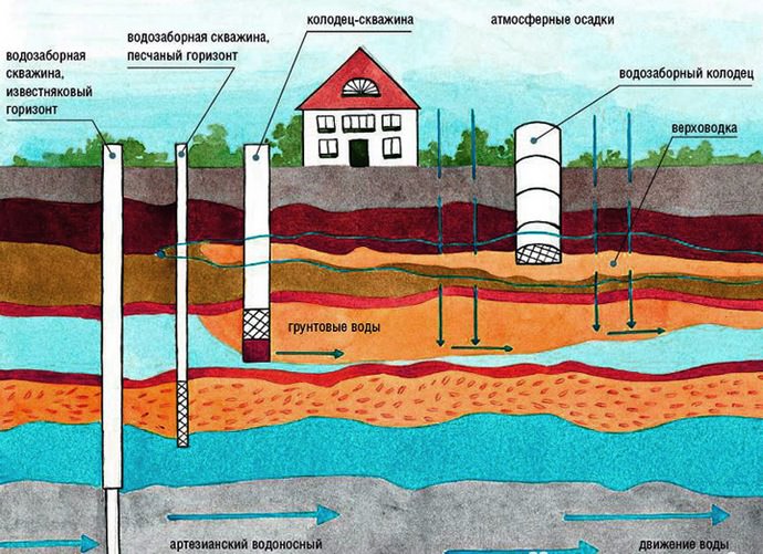
In order to choose the optimal depth at which suitable groundwater passes and to correctly search for an aquifer, some natural factors must be taken into account, since there are many aquifers, and their depth, the quantity and fullness directly depend on the features of the geological structure:
- groundwater lies above a water bed close to the surface;
- above individual aquicludes, perched water can accumulate, on which it is best to dig Abyssinian wells;
- on the territory of the Central part of our country, they are most often located with a depth of 5-40 m;
- groundwater is most often of poor quality and is characterized as unsuitable for food purposes;
- between the aquicludes, at a depth of 15-60 m, there is an aquifer of interstratal waters with sufficiently high quality characteristics and insignificant seasonal fluctuations in filling;
- the main variety of interstratal waters is represented by artesian water-saturated layers at a depth of 50 meters and is distinguished by a constant filling level and high quality.

Of course, the highest quality drinking water can be obtained from the purest artesian sources, but when digging such sources, one must count on high monetary costs. Ground water, especially perch water, is not the best source of water supply, therefore, in order to improve the organoleptic properties of such water, it will be necessary to use a filtration system.
It is also important to remember that the maximum depth of a well made of concrete rings is approximately fifty meters, since at high rates, jamming of the structure with large soil stones can be observed. Thus, it is possible to determine the optimal depth of the water supply source, taking into account the technical capabilities, the structure of the soil and the qualifications of the contractor.
How to find water on the site using frames (video)
The best ways to find water in the garden
To search for a place for arranging an aquifer with your own hands, very much experience is not required. In this case, the folk method or simple technical devices made independently can come to the rescue.
How to find water with copper wire
With the help of copper wire, water-bearing veins are searched quite often. Such a dowsing frame is an L-shaped bent wire with a side length of 25 and 15 cm. For free rotation in the hand, the short ends of the wire must be inserted into wooden tubes. When above the aquifer, the frames rotated 180 degrees close, which allows not only to determine the location of groundwater, but also their boundaries.

Plant Tips
In the presence of a close occurrence of water, the vegetation has a brighter color and juicy appearance. The main natural landmarks are willow, willow and wild sorrel, which most often grow above the water vein. It is also possible to assume the depth of the aquifer according to the following vegetation:
- cattail - up to a meter;
- reeds are sandy and - up to three meters;
- and reed - up to three to five meters;
- wormwood paniculata - up to seven meters;
- whose brilliant - up to eight meters.
- naked licorice, sandy wormwood and yellow - up to ten meters.

The use of willow vine
The finder should hold the ends of the slingshot with the index fingers under the branches. In the process of slowly bypassing the site, the upper part of the slingshot barely noticeably leans down or rises a few millimeters up, which indicates the presence of an underground water vein.

exploration drilling
Exploration of soil for water is one of the most promising methods for obtaining reliable information about the presence of an aquifer. Exploratory drilling is carried out using compact drilling rigs or using a hand drill. Among other things, it is possible to preserve the landscape coverage and, in the shortest possible time, obtain data not only on the depth of water occurrence, but also to study the structure of the soil at the site of the planned water supply source.
Observations of weather and animal behavior
A thirsty horse beats with its hoof, and a dog digs the ground with its paws over a source of water. The chicken will not lay in damp places, but the goose is looking for wet places for laying eggs. Also, the presence of high-lying water can be indicated by accumulations of mosquitoes and midges after sunset, thick fog and very abundant morning dew both on grass and on objects.
Finding water for a well (video)
How to determine the quality of water
The soil and groundwater on the territory of our country are polluted with waste in large quantities, which cannot but affect the quality of water extracted from wells and wells. To protect your health, it is imperative to check the liquid from the source of water supply . At home, testing a taken sample is performed as follows:
- heat a liter of water to a temperature of 20 ° C and check for the absence of taste and smell;
- in the absence of an unpleasant odor, the liquid is heated to 60 ° C, after which a check similar to the first test is carried out.
- clean, odorless and tasteless water should not have even slight staining and turbidity, and a drop of water applied to glass should not leave streaks after drying;
- the degree of hardness is checked by boiling water and assessing the amount of sediment. The presence of a dark gray color of the sediment indicates an excess amount of iron oxides in the water. The presence of a light yellow precipitate allows us to conclude that there is a significant amount of calcium salts and various oxides.

If there are the slightest deviations from the norm, then it is advisable to order a chemical, bacteriological and microbiological examination of the sample in the laboratory. It is important to note that samples obtained from groundwater are slightly hazy due to saturation with iron oxide and salts. Transparency indicators in laboratory conditions are determined by a colorimeter.
Criteria for choosing a location for drilling a well and digging a well when several sources are found
On the territory of the Moscow region, public water reserves are at the level of the first limestone. As a rule, in the southeast, the layer lies at a depth of 30–70 meters, and in the north and northwest, already within 70–100 m. check, the well will be shut down, and a fairly large fine will be imposed on the owner, since such sources of water supply require the execution of special documents.

To obtain high-quality drinking water in large volumes, it is necessary to draw up a package of documentation and coordinate actions with Rospotrebnadzor and other organizations:
- applying to the regional Ministry of Natural Resources for consideration of the possibility of drilling an artesian well;
- departure to the site of the proposed drilling of the commission, which includes hydrogeologists and representatives of Rospotrebnadzor;
- if there is a positive response in the conclusion, a license is issued in accordance with the law "On Subsoil" in the presence of a certificate for the right to use the land plot, a cadastral plan and a master plan for subsequent development with the location of the proposed source of water supply and sanitary protection zone.
To obtain a license, you need to agree on the balance of water consumption and wastewater disposal in the regional water department, as well as the sanitary and epidemiological conclusion of Rospotrebnadzor, after which a well design agreement is drawn up, which is transferred to the SES. If the package of documents is collected correctly, then a drilling license can be obtained within three months. After drilling, it will be necessary to issue a passport for the source of water supply on the basis of permits for state acceptance and state geological examination.
How to dig a well (video)
Despite the fact that drilling an artesian well is accompanied by a long collection of documents, getting your own water source is a popular and very popular event in our country, as it allows you to get uninterrupted and high-quality water supply.
It is very important for the house and the dacha to have water. Some lucky people can connect to a public water supply, but most have to find their own source. How to find water on the site yourself, with your own hands, will be discussed further.
Aquifers and their occurrence
The rock structure is very heterogeneous. Even in one area at a distance of a meter, the "pie" - the composition of the layers and their sizes - can differ significantly. That is why it is so difficult to find water on the site, you have to drill several wells to find a normal aquifer. There are three main aquifers:

I must say that it is not difficult to find a perch on the site. Knowing some features of the vegetation, checking some points, you will determine the location of the water carrier with a fairly high accuracy.
With an aquiferous sandy layer, everything is much more complicated - the depths are serious, you have to focus mainly on the location of the wells near the neighbors, and not some indirect signs.

You can find artesian water on the site only with the help of test drilling. Maps of the occurrence of aquifers can help. Since 2011 in Russia they are in the public domain (without payment). To get a map of your region, you need to send an application to ROSGEOLFOND. You can do this on their official website, or you can download the forms of the required documents, fill them out and send them by mail (with acknowledgment of receipt).
How to find water on the site using folk methods
There are many folk ways to search for water on the site. You can believe in them, you can not believe, but on average, the percentage of hits is 70-80%, which is not lower than that of "scientific" methods, so it's definitely worth a try. These methods require a certain amount of time and attention, but are free (if you look for water in your area yourself), so it is quite possible to combine them - test several methods, and dig / drill at the point where their readings converged.
Paying attention to plants
This item makes sense only if the site is not developed, but "populated" with wild plantations. By where and what plants grow quite accurately, you can determine the depth of water.

All you need is to walk around the site, look where it grows, put poles near the plants found, on which you can indicate the possible depth of water. The table shows a list of plants that can be used to determine the presence of water at a particular depth.
| Plant - indicator | Depth of perch |
|---|---|
| Cattail, wild rosemary, downy birch | 0 - 1 m |
| Sandy reed, buckthorn, wheatgrass, | 1 - 3 m |
| Reed, sucker, sarsazan, spruce, blackberry, raspberry, black poplar | up to 5 m |
| Panicled wormwood, whose brilliant, heather, common pine, bird cherry, English oak, | up to 7-8 meters |
| Licorice, sandy wormwood, yellow alfalfa (up to 15 m), juniper, hazel, cornflower, bearberry, beech | from 3-5 to 10 meters |
There are several types of trees in the table. This is not about arrays, but about single plants, maybe a small group of plants that "bunch" in one place. In the case of herbaceous plants, the opposite is true - these are not single specimens, but clearings that occupy a certain area of \u200b\u200bthe soil.
Using frames
On a long-established site, it will not work to determine by the plants where the water is located. Here other methods will have to be applied. One of the most common and highly probable is the search with the help of frames - aluminum wires bent at an angle of 90 °. This method is also called dowsing. They take two pieces of wire 30-40 cm long. A piece 10 cm long is bent at a right angle.
To make the "readings" more accurate, the short parts are inserted into tubes made from thin branches of a tree-like elderberry. In the cut branches of elderberry, the core is taken out, a bent wire is inserted inside. The ends of the wire must move freely.

Search for water on the site using dowsing - frames
Taking the frames in both hands, the ends of the wires are moved in opposite directions (by 180 °) and they walk around the site with them, observing their condition. Somewhere the frames will converge together, somewhere they will turn in one direction (to the right or left - along the flow of water). It is by these movements that they determine where the water is.
If the frames come together (their ends move at some angle), there is water in this place. Going further, you will see that the frames have diverged again - the aquifer has ended. You can repeat the maneuver from different directions and points, so you can localize the location of the water carrier. If during the reverse pass both frames converged, you have determined the place where you need or. If the frames deviated to the right or left, you need to go in that direction and look for a place where they will converge again.
If the frames are motionless, there is no water on the site or the water carriers are located very deep.
Using a vine (wooden slingshot)
You can find water on the site with a slingshot made of wood. You need to find two branches that grow from the same point. The branches should be thick, at least 1 cm, even. Try to find them of the same thickness. They must be cut off with a piece of the trunk (15-20 cm) on which they grew. You should get a big slingshot.
The leaves are cleaned, the thin ends of the rods are cut off, leaving at least 40 cm on each side of the "fork". The branches are bent to the sides so that the angle is at least 150 °, they are fixed in this position and left to dry. The wood may not be completely dry, but the corner should be preserved.

How to find water on the site with your own hands - this is how they work with a vine
The dried vine is taken by the ends of the fork, held horizontally at shoulder level. In the place where there is water underground, part of the trunk will tend to the ground. In this place it will be possible to drill a well. If there are no deviations, there is no water in the area at a shallow depth.
Determining the amount of water in an underground source
In addition to finding water, it would be nice to determine its volume as well. Approximately they can be estimated using clay pots and silica gel. They take clay pots, pour silica gel into them, tie the neck with cotton cloth. Packed pots are weighed (the weight can be written on the pot itself). The prepared shells are buried in places where water is supposed to be found and left for a day.
A day later, the pots are dug up and re-weighed.

The pot that has gained the most weight marks the vein with the most water.
Finding water - watching nature
You can find water on the site simply by observing nature. You have probably noticed that in some places the fog is the thickest. Sometimes it even resembles a river - meandering stretches in some direction. At such points, groundwater is usually the closest. Still need to in the morning to look at the amount of dew. If in places where the fog was especially thick, there is more of it, then there is definitely water there.

What else can help you find water on the site is the observation of insects. On a warm windless evening, midges often gather in clouds or pillars. And they are located in certain places. Under the places of accumulation of insects are usually located sources of water. If you examine the ground in that place and do not find ant nests, then there really is water there - ants do not make their nests above the water.
How to determine the level of groundwater
You can roughly estimate at what depth the perch is located by the plants growing above it. As you can see from the table above, certain types of plants feel fine if the water is not above and not below a certain depth. So you can roughly estimate how deep the water is.

For areas where there is a natural reservoir nearby - a river, a lake - it is possible to determine the depth of the water occurrence with an accuracy of up to a meter. For this you need a barometer. With it you go down to the water itself, measure the pressure. Then go to the alleged water source and measure the pressure there. The difference is usually expressed in tenths and every tenth (0.1) is equal to a meter of depth. For example, the measurement difference is 0.7 mm/Hg. pillar. This means that the water is at a depth of 7 meters.
What else can help find water on the site? Communication with neighbors who already have a well or well. It is desirable to find out from them where they drilled / dug, how many times, whether there is a lot of water or not, at what depth the water mirror is, what quality it is. By the location of all the nearest successful and unsuccessful attempts at the neighbors, it is possible with a fairly high degree of probability to determine where you have water.
Owners of country houses and plots, in order to establish comfortable living, must ensure uninterrupted water supply. The best option is well equipment. Therefore, many need to know how to find water in the area for the well with their own hands.
To dig a well in the country, you need to find a suitable place where the water vein passes.
Aquifers and location in the ground
It is not easy to find water underground, because it is located between layers of soil through which it cannot seep due to its moisture-resistant composition. The basis of such layers is clay and solid deposits. Clay layers alternate with sand, gravel and pebbles. These layers contain pure water. Those who develop a source of drinking water need to dig to such aquifers.
It should be taken into account that the formation containing water does not have the same parameters throughout its entire length. Somewhere the layering becomes thinner, somewhere it expands and goes to a greater depth. Waterproof layers are also not the same: the arrangement can be horizontal or curved at different angles. Large volumes of sandy layers saturated with moisture lie in the bends and curvature of water-resistant layers.
Effect of Depth on Water Quality
When developing a well, you can stumble upon an aquifer already at a depth of 2-2.5 m from the surface of the earth. Such a source is called a perch and is not used for water supply to private households. The close location to the ground indicates that the water was collected due to melted snow, rain and water from nearby reservoirs. Its quality is low, because there is a risk of seepage of sewage and other dirt.
The headstock is unstable. The layer containing high-quality water is located 15 m from the soil surface. Sand is a natural filter that purifies water from dirt and other dangerous microelements.

Scheme of water occurrence.
Observation in search
You can find a watercourse in the country with the help of your own powers of observation. It is enough to pay attention to the behavior of animals, some natural phenomena and plants.
summer mists
Soil saturated with underground moisture will emit fumes. Early in the morning or in the evening at the end of a hot day, you need to observe the area where the site for the well has been chosen. If fog hovers over the ground, there is water. Optimally, if the fog gathers in clubs in one place or rises in a column, this indicates that there is a lot of water and the layers are located close to the surface. Impermeable layers copy the terrain. Therefore, in ravines and depressions, which are surrounded by highlands, there will be moisture. On flat terrain and slopes, its presence is questionable.
Animal behavior
Dogs in the heat, to cool off, dig small holes and lie down there. Pets feel cool, which means wet places. The close location of moisture-containing layers provides such temperature features of the soil. It is worth watching the poultry. Hens do not lay eggs where the humidity is high. And geese, on the contrary, choose places where they intersect to arrange nests.
Different midges feel places with high soil moisture. Insects huddle together and swarm in the afternoon over wet areas. And field mice, on the contrary, do not like moisture. Rodents will only build nests in dry places, sometimes even climbing trees or into structures that rise above the ground.

You can determine the location of the water by choosing a pet place to stay.
Types of growing plants
Some plants are able to tell if there are underground reservoirs on the site. A birch growing above underground sources will be of small height, with a crooked trunk and growths on it. The herbaceous woodlouse and river beetle also indicate a watercourse in the area of plant growth. An indicator of the presence of groundwater are lingonberries, blackberries and bird cherry.
Pine with a long rod-shaped root, on the contrary, indicates the location of water sources at great depths.
Help from friends and neighbors
If there are houses or summer cottages nearby, you can talk with your neighbors. Perhaps they have already established a water supply and will be able to suggest where a good place to place a well is. It is also recommended to learn about the composition and quality of water, about fluctuations in water levels.
Search Practices
After the observation stage, you can start a practical search using standard and folk methods.
Use of glass containers

Finding water with cans.
Opened dry glass jars upside down are placed on the territory to search for a watercourse. Banks are inspected after 7-8 hours. Where the inner surface of the container is most moistened and the accumulation of condensate is greatest, it is recommended to dig a well.
Application of hygroscopic material
You can find water using hygroscopic materials. These include salt, red brick, silica gel. For this method, it is necessary to prepare an unpainted clay pot and choose a hot period for research so that the soil is dry. Pre-dried salt, brick chips or silica gel should be poured into a pot, the container with the contents weighed, wrapped in gauze or agrofibre and buried in the ground to a depth of 50 cm. After a day, the pot is dug up and weighed again, if the difference in weight is significant, moisture is close.
Almost scientific dowsing methods
Such methods can hardly be classified as scientific, but there is no doubt about their effectiveness.
Aluminum electrodes and wire
Using aluminum frames is a popular method. Aluminum picks up magnetic vibrations in the terrain that are affected by water.
To find a water vein, you need to prepare:
- 2 pieces of aluminum wire 40-45 cm long;
- 2 fragments of a viburnum or elderberry trunk, 10-12 cm long.
A piece of wire 10-12 cm long on both segments must be bent at an angle of 90 ° for handles. Cut wooden blanks along the length of the handles and clean from the core. Insert the wire into the handles so that nothing interferes with unhindered rotation.
To search, you need to go around the territory with frames in your hands, press your elbows to the body, do not clench your fists too much. During the movement, the ends of the frame must be separated in opposite directions. If there is an aquifer on the left or right underground, both ends of the frame will turn in the right direction. If the watercourse is a few meters ahead, the ends of the wire will close.
To make sure that the chosen place is correct, it is recommended to repeat the bypass of the site, but you should move along a different route.
Willow vine at the heart of the search
Willow by nature feels water and reaches for it with branches. It is not difficult to search for the source yourself with the help of a vine. To do this, you need to find a willow branch with 2 ends coming out of one trunk, and dry it. Then you need to take the edges of the vine in each hand and spread them apart so that the angle between them is approximately 150 °, the branch should be directed slightly upwards.
With such a device, you need to bypass the site. Where there is a stream, the willow branch will sink closer to the ground without labor and effort.
For more accurate indicators, it is recommended to bypass the territory:
- from 6 to 7 am;
- afternoon from 16:00 to 17:00;
- in the evening from 20:00 to 21:00;
- at night from 12:00 to 1:00.
Search for water by drilling
Drilling is a more expensive method of finding an aquifer, the cost of developing some wells is equal to the cost of equipping a well with rings. Therefore, drilling with the help of industrial equipment is rarely used in private areas. This type of development is justified in the case of well equipment for industrial large enterprises, where water is used in large volumes.
For a suburban area, a hand-held garden drill is used, the diameter of which is 30 cm. With the help of such a drill, test wells are made with a depth of 5 to 10 m. In the process of drilling, after inserting the tool into the soil, every 15-20 cm with an auger, you need to get the soil and inspect. This is done to prevent breakdowns and to check the level of soil moisture, which indicates the proximity of an aquifer.
This search method is effective and affordable, but the result will largely depend on the skills of the driller.
After the watercourse is found, you should not immediately dig a well hole. You need to make sure that the water found meets the standards. It is recommended to send samples for analysis to the laboratory and wait for the experts' response. If the result is satisfactory, you can end the search.
Water is the basis of life. Every day, a person uses tons of this priceless mineral for his own purposes, so it is constantly lacking. Owners of suburban real estate in all its manifestations seek to provide themselves with life-giving moisture and are engaged in the arrangement of wells or wells. Many are interested in how to find water for a well in their area. It turns out that you can try to do it yourself, using one of the many existing methods.
Where does groundwater accumulate?
Before embarking on a search, it is worth learning a little more about groundwater. Moisture underground accumulates inside the so-called aquifers as a result of precipitation filtration. The liquid, sandwiched between water-resistant layers of soil, consisting of stone or clay, forms reservoirs of various sizes.
Their location is not strictly horizontal, they can bend, forming in such areas a kind of lens filled with water. Their volumes are also very diverse: from a few cubic meters to tens of cubic kilometers.
The scheme of groundwater occurrence is necessary in order to have at least some idea where the source may be.
Closest to the surface, at a depth of only 2-5 m, lies the "top water". These are small reservoirs fed by precipitation and melt water. In dry times, they tend to dry up and cannot be a source of water supply. In addition, water from them can most often be used only for technical purposes. Of greatest interest to humans are deep aquifers containing large reserves of finely filtered water. They usually lie at a depth of 8-10 meters and below. The most valuable water, enriched with minerals and salts, is even deeper, at a distance of about 30-50 m. Getting to it is real, but difficult.
Popular ways to search for water on the site
If desired, the search for water under the well can be done in several ways. The most common of them:
Use of pottery
The ancient method of determining the presence of water involved the use of a clay pot. It was dried in the sun, then turned over and placed on the ground over the place where the water vein was supposed to lie. After a while, the dishes fogged up from the inside, if there really was water under it. Today, this method has been somewhat improved.
You need to take a liter or two of silica gel, which is an excellent desiccant. It is thoroughly dried in the oven and poured into a clay pot. After that, the dishes with the gel are weighed on accurate scales, better than pharmaceutical ones. Then they are wrapped in cloth and buried to a depth of about half a meter in the place where it is supposed to drill a well. Leave it there for a day, then dig it out and carefully weigh it again.
Not one or two aquifers have been found with silica gel yet
The more moisture absorbed into the gel, the closer the water. You can bury several pots at the initial stage and choose a place with the most intensive return of water. Instead of silica gel, an ordinary brick can be used, which is also dried and weighed.
Observations - where do plants grow?
Some plants are excellent indicators of underground water.

Plants will tell you if there is water in the area
For example, a birch growing above a stream will be of low height with a knotty, twisted trunk. The branches of the tree located above it will form the so-called "witch's panicles". The water close to the surface will be shown by thickets of woodlice, a low herbaceous plant. River gravel directly points to the watercourse located under it. But the pine, with its long taproot, says the opposite - in this place the water is deep enough.
Definition by height difference
This method can only be used if there is any body of water or well nearby. You will need an ordinary aneroid barometer, with which pressure will be measured. Based on the fact that for every 13 m of elevation difference, the pressure will drop by about 1 mm of mercury, one can try to determine the depth of groundwater. To do this, you need to measure the pressure at the site of the proposed well and on the shore of the reservoir. The pressure drop is about half a mm Hg. Art. indicates that the depth of the aquifer is 6 or 7 meters.
Observations of natural phenomena
The soil, saturated with underground moisture, will certainly evaporate it. In the early morning or evening at the end of a very hot summer day, you should pay attention to the area where the well is supposed to be equipped.
If fog forms over it, there is water there. It is best if the fog rises in a column or swirls, which means that there is a lot of moisture and it is close enough. You should also be aware that waterproof layers usually follow the terrain. Thus, in the basins and natural depressions, surrounded by hills, there will definitely be water. But on the slopes and plains it may not be.
exploration drilling
How to find water with a frame?
Very often, the search for water for a well is carried out using dowsing, an old and very accurate method for determining the watercourse. Before starting the search, you will need to prepare frames, which are pieces of aluminum wire about 40 cm long. Their ends at a level of about 10 cm are bent at a right angle. It is believed that it is best to insert frames into tubes of elderberry that have been cored. The wire in the tubes must turn absolutely calmly. Also, forks of branches of viburnum, willow or hazel can be used as a frame.

Frames are small pieces of aluminum wire bent at right angles.
- We determine the position of the cardinal points using the compass and mark them on the territory of the site with pegs.
- We take a frame in each hand. We press the elbows to the sides, we direct the forearms parallel to the ground, so that the frame becomes, as it were, an extension of the arms.
- Slowly we cross the territory of the site from north to south, and then from east to west. In a place where there is a watercourse underground, the frames will begin to move and intersect. This place is marked with a peg.
- Considering that water usually lies in the form of peculiar veins, having found one point, we determine the entire watercourse. To do this, we perform the previous operation several times, each time marking with a peg the place where the frames intersected.
- We determine the power and depth of the watercourse. We imagine that we are diving to the depth of our own growth, then to two, three or more such distances. The first time the frame will react to the upper border of the water vein, the second - to the bottom.
A well on the site is a practical solution for providing water supply to the house and personal plot. Methods for self-search of an underground watercourse will determine the presence of water on the site and help make a decision on the possibility of arranging the system. But do not rely too much on them, because all these methods, although considered quite accurate, give only general answers to questions. Only specialists will be able to determine the presence of an aquifer, its depth and thickness absolutely accurately.
Having your own water source on the site is a big advantage. Firstly, you will not be so dependent on the city utility service and in case of breakdowns you always have a fallback option. Secondly, during the irrigation season it is much more profitable to use free water from underground than city water. Read below for ways to find water on the site and take advantage of all the benefits.
Is water everywhere?
It may seem to a little knowledgeable city dweller that it is enough just to drill a well anywhere in the site and he will already have a ready-made well! Unfortunately, it is not.
The groundwater level at the site may not be sufficient for a well or well. Perhaps you will be able to use only the “top water” - the accumulation of precipitation and melt water at a distance of 2-5 meters from the surface. Such a source is not suitable for the whole year and can only be used for technical purposes.

To find not just water, but one that is suitable for all your needs, you will need to conduct a preliminary search for water for a well.
How to determine the groundwater level before construction? Pay attention to plants and wells nearby.
nature signs
Do you know how to find water on the site on your own? Knowledge of nature and observation of it helped our ancestors in this.
Plants
What plants in your area will show that there is water nearby? This:
- willow, alder or maple with a slope to one side;
- wild currant;
- spiraea;
- forest reeds, reeds;
- licorice naked;
- sorrel;
- sedge, nettle;
- goose cinquefoil, horsetail;
- blackberry;
- coltsfoot;
- cowberry;
- wild rosemary;
- bird cherry;
- buckthorn;
- bearberry;
- cattail;
- wormwood panicled, sandy;
- whose brilliant. st]

Insects
A large number of midges and mosquitoes indicates the proximity of groundwater. They need watery soil for reproduction.
Be careful! This area should not be rat and ant holes!
Pets
The behavior of dogs and cats can serve as another indicator of the proximity of water. Dogs usually try to avoid such areas, but cats, on the contrary, feel just fine on them! However, in hot weather, dogs also try to stay close to watery ground, so this is another important observation in finding water.
A horse in dry weather will find a source of water close to the surface and will beat its hoof in this place.
Domestic birds can also tell you the proximity of water: geese try to rush in such places, while chickens avoid them.
Fog and other folk omens
How to find water on the site with your observations and folk wisdom? Take a closer look at the surface of the earth in the evening. Creeping dense fog in the same specific place suggests the proximity of water. In the morning you will find more dew there than in other areas. It is desirable to carry out observations at least a week or two.

Advice! Don't waste your energy and time looking for water in hilly areas. It does not exist on the hills or its level of occurrence will be very deep.
If it seems to you that you have found an aquifer, then you can check this with a pot or jar. Turn them over and leave until the morning. If your suspicions are correct, then they will fog up.
Another sure sign of the proximity of groundwater is the rapid wetting of a beam of salt. This will happen even in dry weather.
Old-fashioned ways to find water: dowsing
The old-fashioned way, which has shown its high efficiency over many centuries, is dowsing or research with the help of a frame.
Everyone can try to apply this method, but a quick search for water on a site with high accuracy is available only to experienced specialists. You can test your own sensitivity with the help of a vine, a bridge and a stream under it. If you feel vibrations in front of the bridge, then you have high sensitivity. Some feel vibrations above the stream itself, others do not notice anything unusual at all.

Previously, to search for water with the help of a vine, branches of various trees (willows, apple trees, elderberries, cherries, hazels, mountain ash), split at an angle of 150, were used. She is held by the "horns" and where they point down, presumably there is water.
Now in dowsing it is customary to use 2 aluminum wires in the shape of the letter L for both hands. The small end is equal to the width of the dowser's palm, and the long end is 40 cm. A small part of the aluminum wire will need to be inserted into hollow wooden tubes that you will hold firmly with your hands. The aluminum tube should move freely in it. Where the wires or the ends of the split vine cross, there is water. Unfortunately, in some geographic latitudes, the efficiency of this method is about 50%, in others - 80-90%. Given the low cost, this is a very attractive way to search. It is advisable to use several expert opinions before drilling. If they diverge, then this may indicate a lack of water in the area.
Modern methods of finding water
Man perfects absolutely everything! Such a question, how to find water for a well in your area, could not be ignored due to its importance. The search method with the highest efficiency is exploratory drilling. Dehumidifiers and terrain surveys are also used.
Exploration drilling
Drilling pits and wells at a depth of up to 10 meters using a conventional garden drill will show not only the presence or absence of water, but also its depth, the presence of floating water, the quality and quantity of inflow, and the thickness of the soil. Unfortunately, the method is not very efficient. On average, for 4 wells, only 1 is with water.

Dehumidifiers
Modern granular desiccants are a great way to find groundwater cheaply. First, silica gel or other agent is thoroughly dried in an oven, then placed in an earthenware or glazed dish. After measuring and fixing the weight of the substance, wrap it with a dense cloth and bury it to a depth of 50 cm. After a day, you need to get the container and weigh the desiccant. The heavier it became, the more likely it is that groundwater is nearby.

This method should not be used during rainy seasons, so that rain moisture does not affect the study. The efficiency of the method is about 65%.
Terrain study
The search for water in the area for drilling a well can be done using a study of the relief. The method is based on knowledge of the occurrence of groundwater: they are concentrated in lowlands and depressions. Hills can hide water only at great depths.
The efficiency of the method is only about 40%.
It can be concluded that modern methods of finding water are not much more effective than in ancient times, with the help of a vine and observations. Which method to choose is up to you.


